About Project
Khun Dan Prakan Chon Dam
About Project
Project Background
Khun Dan Prakarnchon Dam : Royal Initiated Project
On 4 December 1993 (B.E.2536) on the occasion of royal birthday anniversary, His Majesty the King introduced his initiative to the Royal Irrigation Department to consider the project planning and construction of Khlong Tha Dan Dam at Ban Tha Dan, Hin Tang Subdistrict, Mueang District, Nakhon Nayok Province, of which is a part of the Upper Nakhon Nayok Basin Development Project. The objectives are to help villagers at the downstream have water for agriculture, domestic consumption, industrial purpose; and to solve acid soil area; as well as to alleviate the flood that often occurs regularly in the area of Nakhon Nayok Province every year.
Location
Ban Tha Dan, Hin Tang Subdistrict, Mueang District, Nakhon Nayok Province
Objectives
- To be the capital water resource, which can be allocated to the irrigated area of approximately 185,000 rai (29,600 ha): Original Tha Dan Project 6,000 rai (960 ha), Extension Tha Dan Project 14,000 rai (2,240 ha) and Nakhon Nayok Operation and Maintenance Project 165,000 rai (26,400 ha);
- To be the water resource for domestic consumption and industry;
- To alleviate the flood problem in the area of Nakhon Nayok Province;
- To solve the acid soil problem in the area of Nakhon Nayok Province.
General Information
1. Topography The reservoir of Khun Dan Prakarnchon Dam is located in the Nakhon Nayok Basin which is a sub basin of Bang Pakong Basin. Nakhon Nayok Basin covers the area of Mueang, Ban Na, Pak Phli and Ongkharak Districts of Nakhon Nayok Province, with the total area of 2,433 km2. The headwaters of Nakhon Nayok River originates from the area of Khao Yai National Park which is attached northeastward, the mountain peak is about 1,000 - 1,300 m.
2. Climate In general, climate of Nakhon Nayok is influenced by southwest monsoon during May to October.
3. Rainfall Since the basin area is attached with Dong Phaya Yen (Khao Yai) Mountain Range in the northeast, which is the collision front of southwest monsoon; thus making intense rainfall. Average rainfall is approximately 2,600 - 2,900 mm/year.
4. Runoff Average runoff is maximum in August - about 70.87 mcm and minimum in March - about 0.66 mcm. Total runoff is averagely 292.45 mcm.
Implementation Period : 13 years (1997 – 2009)
Project Detail.
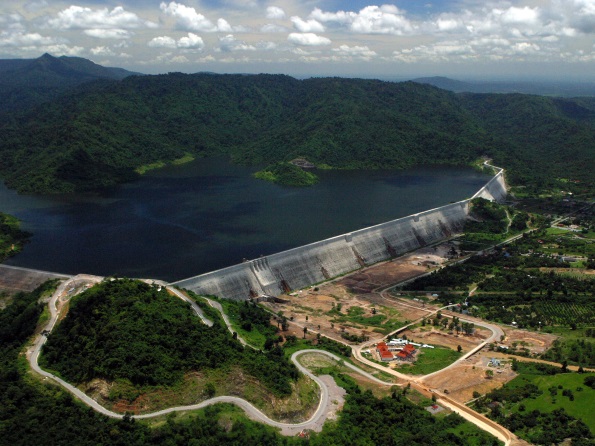
Construction project includes headworks and appurtenant structures together with other components. Reservoir storage capacity is 224 mcm. Reservoir surface area at the normal retention level is totally 3,087 rai (494 ha).
1) Headworks and appurtenant structures
(1) Main Dam
Roller Compacted Concrete Dam : RCC Dam with 93 m high, dam crest level +112 m msl, 2,594 long with the roller compacted concrete volume of 5,470,000 cubic meters.
(2) Spillway
Reinforced concrete structure with maximum discharge capacity of 1,454 m3/sec through 4 openings of weir shape at the level +103.50 m msl controlled by 4 sets of radial gates, size of each set 10.00 x 8.40 m.
(3) River Outlet
Reinforced concrete structure, rate of flow is controlled by fixed wheel gate of 2.00 x 5.00 m size and butterfly valve of 2.0 m diameter with the threshold level of +28.5 m msl. Water is discharged through the iron pipe of 2.0 m diameter and released downstream by hollow jet valve of 1.8 m diameter with the discharge capacity of 42 m3/sec.
(4) Bottom Outlet
Reinforced concrete structure with the threshold level of +29.00 m msl, water is discharged through an opening of 5.0 m wide, 3.0 m high, rate of flow is controlled by fixed wheel gate of 2.50 x 3.90 m size and radial gate of 2.5 x 3.45 m size. Discharge capacity is 182.0 m3/sec, which can reduce the water retention level from +110.00 m msl to +70.00 m msl within 10 days.
(5) Irrigation Outlet
Reinforced concrete structure with discharge through a stainless pipe of 0.90 m diameter with the threshold level of +38.45 m msl, controlled by fixed wheel gate and 2 sets of butterfly valves of 0.70 m diameter. Water is discharged down to the irrigation canal by 2 sets of hollow jet valves of 0.70 m diameter and distributed into the canal totally 6.05 m3/sec.
(6) Diversion Sluice during the dam construction
Closure dam of 12.00 m high with the crest level of +39.00 m msl, 5.00 m wide and 1,084 m long.
Concrete retaining wall at upstream and downstream with the height of 12.00 m and 13.00 m respectively.
Reinforced concrete diversion sluice with 2 openings of 7.00 x 9.00 m and 6.00 x 9.00 m size, able to discharge water of 700 m3/sec (20 year return period) with the threshold level of +27.00 m msl.
(7) Sddle Dam
Earth dam of 46.0 high, crest level of +114 m msl, 8.0 m wide, 350 m long with volume of 1,220,000 m3.
2) Distribution and Drainage System
(1) Original Tha Dan Project and its extension area, total 20,000 rai (3,200 ha)
(2) Nakhon Nayok Operation and Maintenance Project area, 165,000 rai (26,400 ha)
Benefits
- To distribute the water for agricultural area of 185,000 rai (29,600 ha);
- To distribute the water for domestic consumption of 16 mcm/year;
- Farmers receive the benefits in the number of 5,400 households.
- To alleviate the acid soil problem;
- To reduce the damage from flood disaster about 35%.
Work Implementation
Headworks and appurtenant structures have been completed and started to store the water since October 2004 (B.E.2547).


